Is It Safe to Buy a House in Orting’s Lahar Zone?
The short answerFor many buyers, yes, provided you understand the hazard and plan for it. Orting sits on the valley floor inside Mount Rainier’s mapped lahar hazard zone, so living there means learning the siren and your route to high ground, and knowing that a standard homeowners policy is unlikely to cover mudflow damage. A large lahar is unlikely in any given year, but the damage would be severe, which is why the town drills for it.

By Austin Hellickson, Managing Broker, LPT Realty6 min read
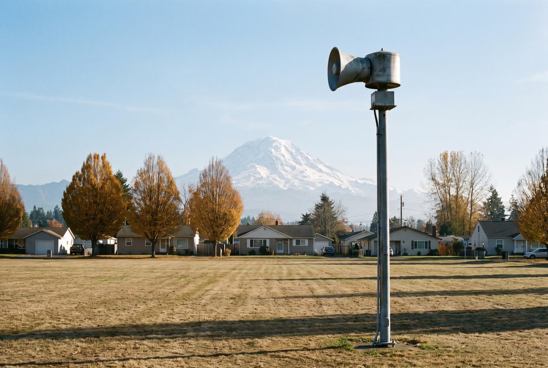
OrtingA warning siren on the valley floor, the mountain close beyond.
What a lahar is, and why Orting sits in the path
A lahar is a volcanic mudflow. Rock, ash, soil, snow and water move together down a river valley, thick as wet concrete and strong enough to carry trees and bridges along with it. It doesn’t need an eruption to start. A section of a volcano’s flank, weakened over a very long time by heat and acidic water, can give way and become one on its own.
Mount Rainier carries more glacier ice than any other Cascade volcano, and much of the rock high on the cone has been weakened by the same hot, acidic water. The USGS ranks it among the highest-threat volcanoes in the United States, largely because of lahars and the number of people living in the valleys below it.
Orting sits between the Carbon and Puyallup rivers, where they leave the foothills and cross a flat valley floor. That flat ground is itself made of old lahar deposits. The Electron Mudflow came down the Puyallup valley roughly five centuries ago and buried the ground where the town now stands. Geologists read those layers as a record of what the valley has already done, and as a fair guide to what it could do again.
None of that makes an event likely in any given year. It means the hazard is mapped and planned for, and a buyer should give it the same attention.
How the sirens, drills and evacuation routes work
The sirens, gray horns on tall poles, are the part of the system you’ll notice first. Pierce County Emergency Management and the state run a network of outdoor warning sirens through the Puyallup and Carbon river valleys, and Orting is inside it. The sirens are tested on a regular schedule so people know the sound. Ask Pierce County Emergency Management when the tests happen.
Up in the river drainages on the mountain, the U.S. Geological Survey maintains instruments that listen for the ground vibration of a passing lahar. A detection triggers the sirens and emergency alerts downstream, buying the valley time.
If the sirens sound for a lahar, the instruction is short: go to high ground, and go on foot if the roads jam. Warning time on the valley floor would be brief. Evacuation route signs point the way out of town toward the hills. The Orting School District runs drills in which students walk out of their buildings toward higher ground, and those drills are the best-known piece of the town’s planning.
For a buyer, the practical step is to drive and then walk the route from any house you’re serious about. Time it. Notice whether it crosses a bridge or funnels onto the same road everyone else in the subdivision would use. Then sign up for Pierce County’s emergency alerts on your phone, because a siren is harder to hear inside a closed-up house on a January night with the furnace running.
Does homeowners insurance cover a lahar?
Probably not, at least under a standard policy. Homeowners policies tend to exclude earth movement and mudflow, and they commonly exclude flood as well. Some policies cover certain volcanic damage, such as ash or blast, but a lahar behaves much more like a flood of mud than like ash on a roof, and the exact policy wording decides how a claim would be handled.
That makes flood insurance the conversation to have. Policies through the National Flood Insurance Program cover mudflow as the program defines it, and private flood insurers also write policies in the area. Whether a particular policy would respond to a lahar is a question for the insurer, so ask a licensed insurance agent to show you the relevant language in writing before your inspection period ends.
If the house also sits in a mapped flood zone along the Puyallup or Carbon, your lender may require flood coverage anyway. The rules about when a new policy takes effect are the same ones covered in the article on buying in the North Bend floodplain. Get quotes early. The premium belongs in your monthly budget next to property taxes and the mortgage payment, before you decide what to offer.
Looking up one address on the hazard maps
Work from the regional map down to the lot.
- Start with the Mount Rainier volcano hazards map from the USGS Cascades Volcano Observatory. It shows the lahar hazard zones down each river valley. Find the street, then the lot.
- Check the parcel on Pierce County’s online maps and ask county planning staff how it is classified for volcanic hazards. Pierce County Emergency Management and the City of Orting can point you to the lahar evacuation routes for that part of town.
- Look at the Washington Geological Survey’s geologic information portal, run by the state Department of Natural Resources. It carries volcanic hazard layers alongside landslide and other geologic data.
- Read the seller disclosure statement and the preliminary title report for anything that mentions hazard areas, and call the City of Orting’s planning staff if something on a map is unclear.
Most of the valley floor in and around Orting sits inside the hazard zone, so the map will rarely separate one house from the one next door. What it does show is how far you are from the edge of the zone. That distance is your walk.
Other valley towns that share the question
Orting gets the headlines because it sits closest to the mountain on the Puyallup side. It isn’t the only town on the map. The USGS hazard zones follow the Puyallup valley down through Sumner, Puyallup and Fife toward the Port of Tacoma. On the White River side, a far older lahar called the Osceola Mudflow spread across much of the ground where Enumclaw and Buckley stand today, so addresses there deserve the same lookup.
Up in the Carbon River country, Wilkeson and Carbonado have their own questions about steep ground and old mine workings, which come up in the article on old coal mines under Black Diamond and Issaquah homes. The town-by-town notes on the places page cover what each of these towns is like to live in.
I bring up the neighbors because some buyers cross Orting off their list, then buy a few miles down the same valley without looking up the new address.
Who Orting suits, and who should look on higher ground
Orting works for people who want a real small town with Rainier filling the end of the valley. The Foothills Trail runs straight through the middle of it, past the big central park, and you can ride toward South Prairie and Buckley or back toward Puyallup without getting in a car. Older homes sit near downtown and newer subdivisions spread across the valley floor, so there is range in what you can buy. For plenty of households, the lahar becomes one more fact of the place, like the traffic on SR 162 at the wrong hour. They learn the plan and get on with living there.
It suits people less well if the regular siren test would sit on your chest for a day afterward. It also deserves a harder look if someone in your household can’t walk far or quickly, since the plan leans on people moving on foot when the roads fill.
If that describes you, the plateaus above the valley are close. Bonney Lake and the South Hill area of Puyallup keep you near the same trails and the same view of the mountain, while putting you above the flow path.